Instructions
Czech Orienteering Cup 2014 (5th a 6th race)
INOV-8 CUP Czech Orienteering A Cup 2014 (5th a 6th race)
Orienteering B Cup Moravia (4th a 5th race)
8th Race of South Moravia League
Public Orienteering Race
WRE – World Ranking Event – middle distance
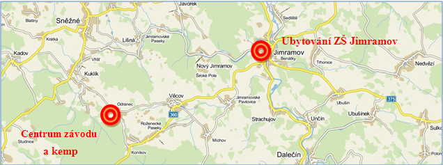
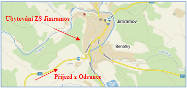
Odranec, Czech Republic
Date:
Saturday 7th June 2014 – long distance – National Ranking Event
Sunday 8th June 2014 – middle distance – National Ranking Event
Organized by:
Czech orienteering association (ČSOS) and KOS Tesla Brno (TBM)
Jury:
Members: Milan Venhoda, Michal Jedlička, Petr Turczer
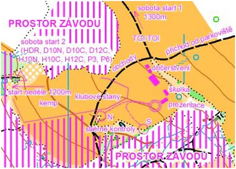
Competition centre:
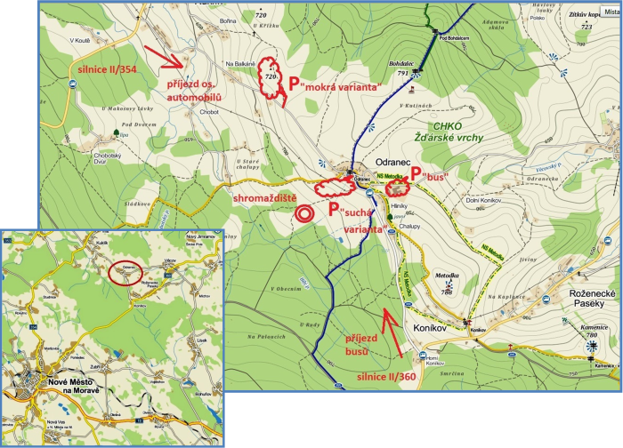
Odranec, meadow south of the village, 49°36’41.069″N, 16°7’48.308″E
Arrival:
Arrival of coaches from the NW from the road II/354 and municipality Kuklík. Arrival by bus only from S by road II/360 from the village Koníkov. Due to the cramped conditions on the roads and on arrival in the village Odranec, please follow the recommended route of arrival strictly.
Parking:
Parking of vehicles will be organized in two options depending on the weather , see the Map No. 2 below of parking and arrival published also on the website of the race.
– „Dry option“ – parking on the meadow directly below the center of the village Odranec , 49 ° 36’49 .429 “ N , 16 ° 8’12 .510 “ E, parking distance „dry version“ – the center of the plant 400m.
– „Wet option“ – parking on the meadow adjacent to the road Kuklík – Odranec ,
49 ° 37’12 .226 “ N , 16 ° 7’41 .054 “ E, parking distance „wet option“ – the center of the race 1500m, the path marked with a green and white ribbons .
In the case of „wet option“ it will be possible to park personal vehicles of families with preschool children in the area of Odranec farm .
The price for parking is 40 CZK / weekend, respectively 20, – CZK per day .
Parking in the entire village Odranec as well as on access roads is strictly prohibited.
Registration:
In the competition centre:
Saturday 9:30 a.m. – 11:00 a.m.
Sunday 8:30 a.m. – 9:30 a.m.
Changing:
Place for club tents will be reserved in competition centre.
Maps:
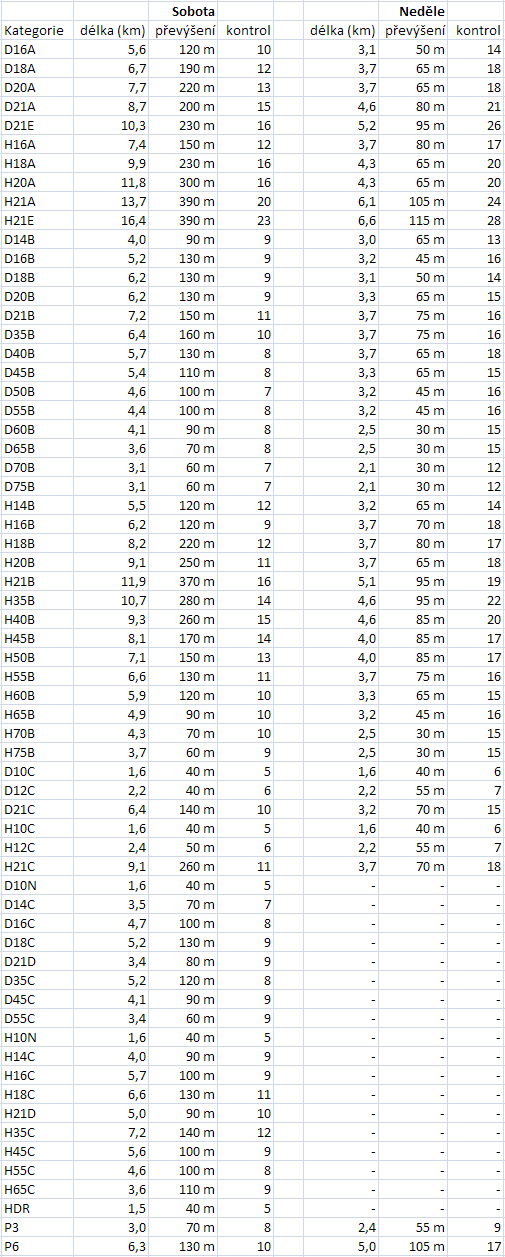
Saturday (long distance):
Kopeček 822 (for category H / D 16-40: 1:15 000, e = 5m), size A3
Kopeček 822 – sever (for other categories 1: 10,000), size A3
offset printing by Žaket.
Sunday (middle distance):
Křišťálová studánka (1 : 10 000, e=5 m), size 268×297 for WRE categories and A4 for other categories,
offset printing by Žaket.
Maps for both days were prepared by Petr Mareček and Martin Kratochvíl, state May 2014, map key ISOM 2000; maps for both days will be waterproof.
Warning:
Optically denser but runable forest is in accordance with the classification of ISOM 2000 symbol mapping 405 (white). It is forbidden to enter the area on the map marked with 415 – cultivated area (field) 527 – private, 709 – and 711-bounds area – prohibited action. It is forbidden to enter the fenced enclosed symbol 524 – high fence. Violations of these prohibitions will be in critical areas thoroughly monitored and punished by disqualification.
Special map symbols:
green cross – rootstock
green circle – significant tree
brown cross – platform
black circle – triangulation rod
black cross – man-made object (shelter)
Terrain:
Physically demanding terrain with typical highland ground, vegetation varied from easy to run areas to areas with reduced visibility and runability, moderate network of roads, sloping terrain at an altitude of 650-810 above sea level, in the lower parts streams and marches to be found.
Punching system:
SportIdent – it is possible to hire SportIdent card (40 CZK or 2 EUR per day)
In case of failure of SI units use punching pliers and mark it in to designated boxes on the map.Show map with hand stamping at finish for manual inspection.
Control Description:
For both days, descriptions will be available only at the event centre. The exceptions are the WRE categories on Sunday, having descriptions on the map.
Distances:
Parking “Dry option” – competition centre 400 m cars; 600 m buses
Parking “Wet option” – competition centre 1 500 m cars; 600 m buses
Competition centre – start 1200 m (marked with blue-white ribbons)
Competition centre – finish 0 m
Start List:
The start list for middle distance for M21-E and W21-E (WRE) was prepared based on IOF FootO World Ranking. Issued on 30th April 2014. Competitors so far not listed in FootO World Ranking, or those who have not provided their WRE ID in their initial registration to this even, were drawn at the beginning of the start list.
Individual interval start is used.
Start 000:
Interval – Saturday 12:00 a.m. (Long) – National Ranking Event
Start 1: All categories except the categories listed at the Start 2 Distance start – event centre – 1300 meters, elevation 0 m. Marked with blue and white ribbons. Two mobile toiletes available.
Start 2: Categories: HDR, D10N, D10C, D12C, H10N, H10C, H12C, P3, P6, distance start – event centre – 100 m, elevation 0 m. Marked with arrows, start is visible from event centre.. HDR, P3 and P6 categories does not have a predetermined starting times and athletes can start at any starting time ranging from 10 to 120
Interval – Sunday 10:00 a.m. (Middle)
Distance start – event centre – 1200 m, 25 m elevation. Marked with blue and white ribbons. Category P3 and P6 does not predetermined start times and athletes can start at any starting time ranging from 10 to 120
Number Bibs:
WRE, Czech Cup competitors will take themselves number bibs at the start area.
Compulsory Route:
start – start of orientation
Last control point – finish
They are labelled red ribbons or corridors.
Embargoed Areas:
It is not permitted to enter forest around Competition Centre, except on the way to start on the marked path.
Roads in the north-western and south-eastern edge of the map are for racers prohibited. It is busy road on which the cars are moving at high speeds. On the map they are marked with road 711 – prohibited course.
In the northern part of the map and the near Competition centre there are small zone No. 1 of Protected Nature Area, to which access is prohibited. in the map it is marked with 709 – inaccessible area.
In the Competition Area new pond is under construction . This area is marked on the map with symbol 709 – inaccessible area.
Note: During the race, competitors will be crossing forest road, with occasionally cars and cyclists traffic. Please be careful when crossing.
The forest logging takes place, be careful. Insignificant traces of machines are not marked on the map.
Time Limit:
Saturday 180 min all categories. Sunday 90 minutes all categories.
Finish closed:
Saturday 18.30, Sunday 15.00
Release of maps:
Sunday 13.30
Firs aid:
In finish area.
Refreshment:
Water or juice in finish. Saturday there will be refreshment stations in the forest (juice + water) – in the map marked with symbol 713.
Washing:
In the event centre, only cold water.
WC:
Mobile WC in the competition centre.
Kindergarten:
In the event centre (both days).
Pricegiving ceremony:
Saturday at 17:00, Sundays at 14:30 am at the event centre. First three competitors in categories D21E, H21E, D16A, D18A, D20A, H16A, H18A, H20A, D14b, H14B, D10N, D10C, D12C, H10N, H10C, H12C, in the other categories are announced only winners. In the category HDR everyone receives a prize immediately after the race – when reading the chip.
Information:
Petr Strejček, petr.strejcek@qsi.cz , mobil. +420 603 565 614
Refresments:
In the event center two food stalls will be available.
Courses:
Event officials:
Competition director: Petr Strejček
Main controller: Luděk Krtička, R1
Course setting: Zdeněk Liščínský (middle distance) – R2
IOF Event Advisor: Juraj Petrinec (Slovakia)
All competitors are reminded that orienteering is an adventure sport and that they take part voluntarily and at their own risk, without any claim in case of injury during or because of this competition later on.
Competition centre:
Parking: